


Lacs et col de l'Aupillon

Clo0413
User
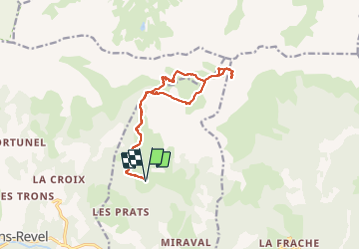

Length
15.1 km

Max alt
2698 m

Uphill gradient
825 m
Km-Effort
26 km

Min alt
1881 m

Downhill gradient
822 m
Boucle
Yes
Creation date :
2021-07-23 06:49:04.294
Updated on :
2021-07-24 09:35:13.313
7h00
Difficulty : Difficult

FREE GPS app for hiking
 SityTrail
IGN / Geographical institutes
SityTrail Plus
The world is yours!
About
Trail Walking of 15.1 km to be discovered at Provence-Alpes-Côte d'Azur, Alpes-de-Haute-Provence, Les Thuiles. This trail is proposed by Clo0413.
Positioning
Country:
France
Region :
Provence-Alpes-Côte d'Azur
Department/Province :
Alpes-de-Haute-Provence
Municipality :
Les Thuiles
Location:
Unknown
Start:(Dec)
Start:(UTM)
305728 ; 4920937 (32T) N.
Comments